Royal, Utah Facts
| Local Time | |
| Timezone | Mountain Daylight Time |
| Lat & Lng | 39.74607, -110.88016 |
Map of Royal, Utah
Interactive Map
Recent Nearby Earthquakes
Magnitude 3.0 and greater
| Date▼ | Time↕ | Magnitude↕ | Distance↕ | Depth↕ | Location↕ | Link |
|---|---|---|---|---|---|---|
| 4/10/19 | 4:32 AM | 3.17 | 77 km | 17,460 m | 15km ESE of Ferron, Utah | usgs.gov |
| 12/20/18 | 12:49 PM | 3.12 | 75.5 km | 4,840 m | 14km E of Manti, Utah | usgs.gov |
| 5/25/16 | 1:01 PM | 4.03 | 84.7 km | 15,740 m | 41km NNW of Duchesne, Utah | usgs.gov |
| 6/29/14 | 4:52 AM | 3.1 | 59.1 km | 8,800 m | 12km S of Mount Pleasant, Utah | usgs.gov |
| 6/29/14 | 12:56 AM | 4.2 | 58.5 km | 8,800 m | 11km S of Mount Pleasant, Utah | usgs.gov |
| 2/16/12 | 8:20 AM | 3 | 59.3 km | 4,500 m | Utah | usgs.gov |
| 2/16/12 | 8:20 AM | 3.01 | 59.1 km | 9,970 m | Utah | usgs.gov |
| 2/4/12 | 11:27 AM | 3.64 | 61.2 km | 12,660 m | Utah | usgs.gov |
| 2/4/12 | 11:27 AM | 3.7 | 63.4 km | 8,800 m | Utah | usgs.gov |
| 11/12/11 | 5:15 AM | 3.2 | 68.2 km | 15,500 m | Utah | usgs.gov |
Source: U.S. Geological Survey (USGS)
Royal, Utah
Royal is a ghost town that existed in the early 1900s as a small coal mining town in Carbon County, Utah, United States. Originally called Bear Canyon, the town was renamed Cameron, Rolapp, and finally Royal when the Royal Coal Company purchased it, ..
Royal, Utah Wikipedia Page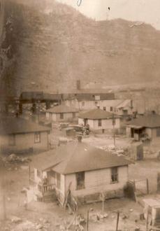


About Our Data
The data on this page is estimated using a number of publicly available tools and resources. It is provided without warranty, and could contain inaccuracies. Use at your own risk.