Sipán Facts
| Local Time | |
| Timezone | Peru Standard Time |
| Lat & Lng | -6.80703, -79.60122 |
Map of Sipán
Interactive Map
Recent Nearby Earthquakes
Magnitude 3.0 and greater
| Date▼ | Time↕ | Magnitude↕ | Distance↕ | Depth↕ | Location↕ | Link |
|---|---|---|---|---|---|---|
| 3/7/19 | 4:05 AM | 4.9 | 65.4 km | 41,060 m | 37km NNE of Chongoyape, Peru | usgs.gov |
| 10/16/16 | 1:04 PM | 5 | 62.1 km | 40,740 m | 28km SW of Pimentel, Peru | usgs.gov |
| 6/14/16 | 12:53 PM | 4.1 | 51.4 km | 35,000 m | 9km E of Chepen, Peru | usgs.gov |
| 1/31/16 | 6:29 PM | 3.9 | 79.5 km | 64,000 m | 10km SE of San Pedro de Lloc, Peru | usgs.gov |
| 6/25/15 | 3:07 AM | 4 | 76.2 km | 57,990 m | 30km WSW of Morrope, Peru | usgs.gov |
| 5/15/14 | 10:43 PM | 5.1 | 91.7 km | 64,160 m | 16km NNW of Paijan, Peru | usgs.gov |
| 8/17/13 | 1:29 PM | 4.1 | 97.8 km | 67,750 m | 61km WSW of Pimentel, Peru | usgs.gov |
| 8/12/13 | 2:27 AM | 4.2 | 80.3 km | 58,000 m | 28km NNW of Morrope, Peru | usgs.gov |
| 10/19/12 | 3:42 PM | 4.1 | 99.6 km | 30,000 m | off the coast of northern Peru | usgs.gov |
| 3/24/12 | 6:52 AM | 4 | 65.5 km | 82,500 m | near the coast of northern Peru | usgs.gov |
Source: U.S. Geological Survey (USGS)
Sipán
Sipán is a Moche archaeological site in northern Peru in the Lambayeque Valley, that is famous for the tomb of Lord of Sipán (El Señor de Sipán), excavated by Walter Alva and his wife Susana Meneses beginning in 1987. The city of Sipán is dated from ..
Sipán Wikipedia Page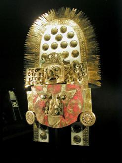


About Our Data
The data on this page is estimated using a number of publicly available tools and resources. It is provided without warranty, and could contain inaccuracies. Use at your own risk.