Kimjongsuk County Facts
| Local Time | |
| Timezone | Korean Standard Time |
| Lat & Lng | 41.40833, 127.76472 |
Map of Kimjongsuk County
Interactive Map
Recent Nearby Earthquakes
Magnitude 3.0 and greater
| Date▼ | Time↕ | Magnitude↕ | Distance↕ | Depth↕ | Location↕ | Link |
|---|---|---|---|---|---|---|
| 12/16/04 | 6:59 PM | 4 | 47.4 km | 10,000 m | China-North Korea border region | usgs.gov |
Source: U.S. Geological Survey (USGS)
Kimjongsuk County
Kimjŏngsuk County is a kun, or county, in Ryanggang province, North Korea, along the Yalu River. Originally part of Samsu, the county was made a separate entity in 1952. Formerly known as Sinpa, it was named in 1981 after Kim Jong-suk, the mother of ..
Kimjongsuk County Wikipedia Page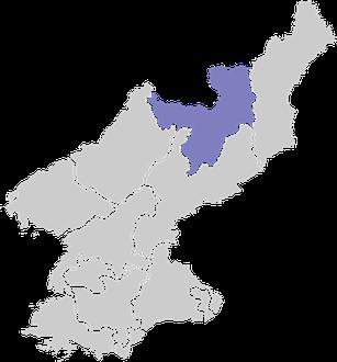

About Our Data
The data on this page is estimated using a number of publicly available tools and resources. It is provided without warranty, and could contain inaccuracies. Use at your own risk.