Industries
Business Distribution by Industry in Sahab district
| Industry Description | Number of Establishments |
|---|---|
| Religion | 6 |
Sahab district Facts
| Neighborhoods | Sahab, Al Makhfar, Al Madina As Sinaiyya, Hinurbba, Hanu Rubah |
| Local Time | |
| Timezone | GMT+03:00 |
| Lat & Lng | 31.87032, 36.00479 |
Map of Sahab district
Interactive Map
Neighborhoods in Sahab district
Percentage of businesses by neighborhood in Sahab district
Area Codes
Percentage Area Codes used by businesses in Sahab district
Price Distribution
Business distribution by price for Sahab district
Recent Nearby Earthquakes
Magnitude 3.0 and greater
| Date▼ | Time↕ | Magnitude↕ | Distance↕ | Depth↕ | Location↕ | Link |
|---|---|---|---|---|---|---|
| 7/30/15 | 2:39 AM | 4.2 | 72.5 km | 13,000 m | 24km NNE of `En Boqeq, Israel | usgs.gov |
| 12/2/07 | 7:38 AM | 4 | 49 km | 10,000 m | Dead Sea region | usgs.gov |
| 11/20/07 | 11:21 PM | 3.2 | 44.6 km | 5,000 m | Dead Sea region | usgs.gov |
| 11/20/07 | 9:18 AM | 4.6 | 47.2 km | 10,000 m | Dead Sea region | usgs.gov |
| 2/9/07 | 10:14 PM | 4.5 | 98.9 km | 15,000 m | Dead Sea region | usgs.gov |
| 2/9/07 | 10:12 PM | 4 | 98.2 km | 2,000 m | Dead Sea region | usgs.gov |
| 11/18/06 | 2:57 AM | 3.1 | 59.7 km | 10,000 m | Dead Sea region | usgs.gov |
| 9/17/06 | 8:22 AM | 4 | 53.2 km | 1,000 m | Dead Sea region | usgs.gov |
| 9/9/06 | 4:58 AM | 4.5 | 51.4 km | 1,000 m | Dead Sea region | usgs.gov |
| 10/3/05 | 4:05 AM | 4.4 | 48.4 km | 10,000 m | Dead Sea region | usgs.gov |
Source: U.S. Geological Survey (USGS)
Sahab district
Sahab (Arabic:سحاب) is a district number 23 out of 27 in Amman in the Kingdom of Jordan, south east of the capital Amman. Sahab is well known for its Industrial Estate, the Islamic Cemetery, and Kahf of Raqeem site mentioned in the Qur'an (Surat al-K..
Sahab district Wikipedia Page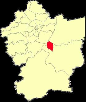

About Our Data
The data on this page is estimated using a number of publicly available tools and resources. It is provided without warranty, and could contain inaccuracies. Use at your own risk.