Taq Bostan Facts
| Local Time | |
| Timezone | Iran Standard Time |
| Lat & Lng | 34.38540, 47.13420 |
Map of Taq Bostan
Interactive Map
Recent Nearby Earthquakes
Magnitude 3.0 and greater
| Date▼ | Time↕ | Magnitude↕ | Distance↕ | Depth↕ | Location↕ | Link |
|---|---|---|---|---|---|---|
| 8/3/19 | 12:26 AM | 4.2 | 84.7 km | 10,000 m | 33km SW of Javanrud, Iran | usgs.gov |
| 6/12/19 | 11:21 PM | 4.1 | 85.6 km | 10,000 m | 15km NNW of Javanrud, Iran | usgs.gov |
| 1/5/19 | 7:19 PM | 4.2 | 85.5 km | 10,000 m | 30km SW of Javanrud, Iran | usgs.gov |
| 12/4/18 | 8:23 PM | 3.7 | 84.7 km | 10,000 m | 24km E of Paveh, Iran | usgs.gov |
| 11/17/18 | 7:19 PM | 4.5 | 85.9 km | 10,000 m | 35km ENE of Sarpol-e Zahab, Iran | usgs.gov |
| 8/26/18 | 8:25 AM | 4 | 78.5 km | 10,000 m | 23km SW of Javanrud, Iran | usgs.gov |
| 8/26/18 | 12:53 AM | 4.3 | 67.4 km | 10,000 m | 9km S of Javanrud, Iran | usgs.gov |
| 8/25/18 | 11:25 PM | 4.4 | 84.9 km | 10,000 m | 36km ENE of Sarpol-e Zahab, Iran | usgs.gov |
| 8/25/18 | 10:40 PM | 4.3 | 85.6 km | 10,000 m | 29km SW of Javanrud, Iran | usgs.gov |
| 8/25/18 | 10:13 PM | 6 | 85.7 km | 10,000 m | 32km SW of Javanrud, Iran | usgs.gov |
Source: U.S. Geological Survey (USGS)
Taq Bostan
Taq wa San or Taq-e Bostan (Persian: طاق بستان, "arch of the garden") is a site with a series of large rock reliefs from the era of Sassanid Empire of Persia, the Iranian dynasty which ruled western Asia from 226 to 650 AD. This example of Sassanid..
Taq Bostan Wikipedia Page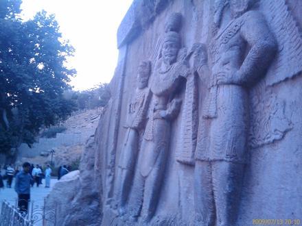

About Our Data
The data on this page is estimated using a number of publicly available tools and resources. It is provided without warranty, and could contain inaccuracies. Use at your own risk.