Industries
Business Distribution by Industry in Vrboska
| Industry Description | Number of Establishments |
|---|---|
| Other accommodation | 46 |
| Restaurants | 15 |
| Hotels and motels | 11 |
| Real estate | 11 |
| Holiday homes, cabins and resorts | 9 |
| Travel agencies | 7 |
| Bars, pubs and taverns | 7 |
| Cafes | 5 |
| Apartments | 5 |
Vrboska Facts
| Local Time | |
| Timezone | Central European Summer Time |
| Lat & Lng | 43.18222, 16.67083 |
| Postal Codes | 21463 |
Map of Vrboska
Interactive Map
Area Codes
Percentage Area Codes used by businesses in Vrboska
Price Distribution
Business distribution by price for Vrboska
Recent Nearby Earthquakes
Magnitude 3.0 and greater
| Date▼ | Time↕ | Magnitude↕ | Distance↕ | Depth↕ | Location↕ | Link |
|---|---|---|---|---|---|---|
| 3/30/19 | 2:08 AM | 4.4 | 60.4 km | 10,000 m | 17km NNW of Solin, Croatia | usgs.gov |
| 2/3/18 | 12:53 PM | 4.6 | 25.8 km | 10,000 m | 5km W of Donja Brela, Croatia | usgs.gov |
| 3/13/17 | 1:31 AM | 4.1 | 60.2 km | 16,360 m | 7km SSW of Orguz, Bosnia and Herzegovina | usgs.gov |
| 12/9/16 | 12:57 PM | 4.4 | 47.2 km | 22,520 m | 2km SSE of Trogir, Croatia | usgs.gov |
| 12/29/13 | 6:54 AM | 4.2 | 47.5 km | 10,000 m | 13km NNE of Orebic, Croatia | usgs.gov |
| 11/18/13 | 7:58 AM | 4.9 | 56.1 km | 19,920 m | 10km ESE of Otok, Croatia | usgs.gov |
| 2/4/13 | 4:29 AM | 4 | 60.2 km | 10,000 m | Croatia | usgs.gov |
| 1/17/13 | 1:21 PM | 4.1 | 54.1 km | 8,600 m | Croatia | usgs.gov |
| 5/5/08 | 6:13 PM | 3.7 | 52.1 km | 2,300 m | Adriatic Sea | usgs.gov |
| 4/14/08 | 2:13 PM | 3 | 40.6 km | 10,000 m | Croatia region | usgs.gov |
Source: U.S. Geological Survey (USGS)
Vrboska
Vrboska is a settlement on the north coast of the island of Hvar in Dalmatia, Croatia, in the Municipality of Jelsa. Founded in the 15th century as a fishing harbour, Vrboska is best known for the fortress Church of Sv. Marija (St Mary), built as a r..
Vrboska Wikipedia Page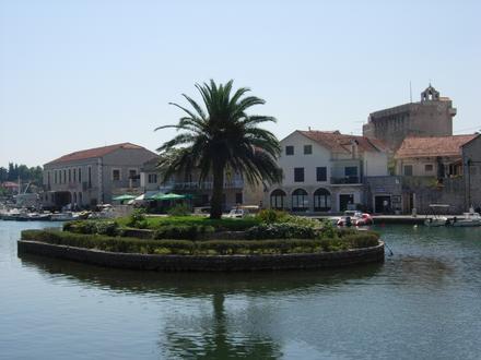


About Our Data
The data on this page is estimated using a number of publicly available tools and resources. It is provided without warranty, and could contain inaccuracies. Use at your own risk.