Categories in Valtura
Industries
Business Distribution by Industry in Valtura
| Industry Description | Number of Establishments |
|---|---|
| Other accommodation | 27 |
| Car rental | 9 |
Valtura Facts
| Local Time | |
| Timezone | Central European Summer Time |
| Lat & Lng | 44.90528, 13.95778 |
Map of Valtura
Interactive Map
Area Codes
Percentage Area Codes used by businesses in Valtura
Postal Codes
Percentage of businesses by Postal Codes in Valtura
Recent Nearby Earthquakes
Magnitude 3.0 and greater
| Date▼ | Time↕ | Magnitude↕ | Distance↕ | Depth↕ | Location↕ | Link |
|---|---|---|---|---|---|---|
| 8/8/17 | 9:35 AM | 4 | 60.8 km | 10,000 m | 3km E of Omisalj, Croatia | usgs.gov |
| 4/22/14 | 8:58 AM | 4.5 | 84.3 km | 4,600 m | 6km SE of Pivka, Slovenia | usgs.gov |
| 12/23/08 | 7:07 PM | 3.6 | 50.3 km | 10,000 m | Adriatic Sea | usgs.gov |
| 10/21/08 | 8:12 AM | 3.4 | 87 km | 10,000 m | Slovenia | usgs.gov |
| 10/6/08 | 9:19 AM | 3.3 | 57.5 km | 10,000 m | Slovenia-Croatia border region | usgs.gov |
| 12/15/07 | 10:12 PM | 3 | 65 km | 10,000 m | Slovenia-Croatia border region | usgs.gov |
| 8/13/07 | 1:58 PM | 3.9 | 53 km | 8,900 m | Italy-Slovenia-Croatia border region | usgs.gov |
| 6/10/07 | 8:48 PM | 3.2 | 65.1 km | 10,000 m | Croatia | usgs.gov |
| 12/29/06 | 2:14 AM | 3.4 | 82.8 km | 10,000 m | Adriatic Sea | usgs.gov |
| 8/7/06 | 4:59 AM | 3 | 73.3 km | 10,000 m | Croatia | usgs.gov |
Source: U.S. Geological Survey (USGS)
Nesactium
Nesactium (Istrian dialect: Vizače, Croatian: Nezakcij, Italian: Nesazio) was an ancient fortified town and hill fort of the Histri tribe. Its ruins are located in southern Istria, Croatia, between the villages of Muntić and Valtura.
Nesactium Wikipedia Page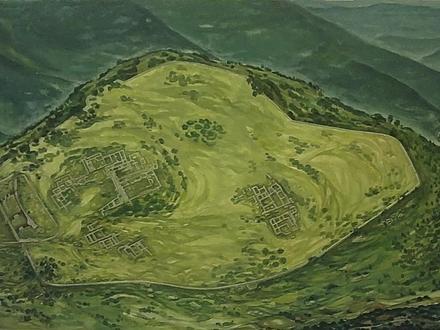


About Our Data
The data on this page is estimated using a number of publicly available tools and resources. It is provided without warranty, and could contain inaccuracies. Use at your own risk.