Maríai Facts
| Local Time | |
| Timezone | Eastern European Summer Time |
| Lat & Lng | 37.81711, 20.67721 |
Map of Maríai
Interactive Map
Recent Nearby Earthquakes
Magnitude 3.0 and greater
| Date▼ | Time↕ | Magnitude↕ | Distance↕ | Depth↕ | Location↕ | Link |
|---|---|---|---|---|---|---|
| 7/29/19 | 4:18 AM | 3.2 | 10.7 km | 10,000 m | 15km WNW of Katastarion, Greece | usgs.gov |
| 10/30/18 | 4:57 AM | 4.2 | 11.2 km | 10,000 m | 19km W of Katastarion, Greece | usgs.gov |
| 8/4/08 | 9:03 PM | 3.3 | 11.6 km | 5,000 m | Ionian Sea | usgs.gov |
| 7/24/08 | 4:02 AM | 3.3 | 12.5 km | 27,000 m | Ionian Sea | usgs.gov |
| 9/27/07 | 12:59 AM | 3.1 | 1.5 km | 11,000 m | Ionian Sea | usgs.gov |
| 11/9/06 | 9:51 PM | 3.7 | 12.3 km | 16,000 m | Ionian Sea | usgs.gov |
| 10/11/06 | 7:41 AM | 4.2 | 3.2 km | 7,000 m | Ionian Sea | usgs.gov |
| 7/16/06 | 3:40 AM | 3 | 15.5 km | 22,000 m | Ionian Sea | usgs.gov |
| 4/21/06 | 9:28 PM | 4 | 13.4 km | 100 m | Ionian Sea | usgs.gov |
| 4/12/06 | 9:22 PM | 3.8 | 14.1 km | 4,000 m | Ionian Sea | usgs.gov |
Source: U.S. Geological Survey (USGS)
Maries
Maries (Greek: Μαριές) is a mountain settlement on Zakynthos island, Greece. The village itself is named after both Mary Magdalene and Mary of Klopas. Traditional stories tell of Mary Magdalene having dropped anchor at Porto Vromi in order to spread ..
Maries Wikipedia Page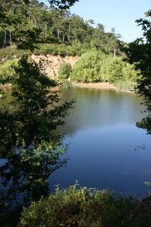


About Our Data
The data on this page is estimated using a number of publicly available tools and resources. It is provided without warranty, and could contain inaccuracies. Use at your own risk.